National Geographic
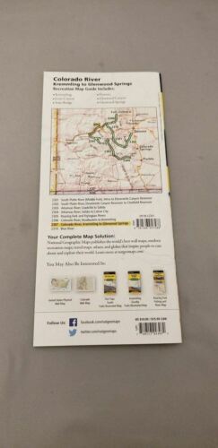
Colorado River Kremmling-Glenwood Fish/Recreation Map Guide 2307
Colorado River Kremmling-Glenwood Fish/Recreation Map Guide 2307
Couldn't load pickup availability
BRAND NEW National Geographic Arkansas River Leadville to Salida Fishing Recreation Map Guide.
Waterproof Tear-Resistant Topographic Fishing & River Map
The Colorado River, Kremmling to Glenwood Springs Fishing & River Map Guide is designed to be the perfect companion for anyone recreating on this section of the mighty Colorado river. Traveling about 94 miles and dropping just shy of 1,500 feet in elevation, the section of the Upper Colorado River represented in this mapfrom Kremmling to Glenwood Springswinds through diverse landscapes. The river passes through Gore Canyon, Radium State Wildlife Area, and Glenwood Canyon, supporting a variety of ecosystems as it morphs into a powerful and mighty waterway known for prolific insect life, quality-size brown and rainbow trout and mountain whitefish (with the occasional native cutthroat), wildlife viewing opportunities, and superb cultural and historical features.
The Colorado River in this sections starts with the class V+ rapids just downstream of Kremmling in Gore Canyon. After existing Gore Canyon the river flows past State Bridge and Dotsero before entering Glenwood Canyon where the river once again generates impressive rapids with names like "Upper Death". Each section of the Colorado River is unique with a different combination of access, river flow, and recreational opportunities.
Each Fishing & River Map Guide includes detailed river maps at a scale of 1 inch = 1/2 mile. At this scale every turn in the river and rapid is clearly shown and labeled. Each page is centered on the river and overlaps with the adjacent pages so finding any location along the river is easy. The maps include rapids, river miles, access points, private and public lands, gaging stations, recreation sites, and more. Also included are stream flow charts, hatch charts, and a table of river access points.
More convenient and easier to use than folded maps, but just as compact and lightweight, National Geographics Fishing & River Map Guide booklets are printed on "Backcountry Tough" waterproof, tear-resistant paper with stainless steel staples. A full UTM grid is printed on the map to aid with GPS navigation.
Features:
- Accurate topography/terrain with clearly labeled river details
- Full UTM grid for GPS use
- Complete fishing details for the serious fisherman
- Includes stream flow charts & hatch charts
- Table of river access points
- River miles, private & public lands, gaging stations, recreation sites, and more
- Booklet format - more convenient and easier to use than folded maps
- Waterproof and tear-resistant paper with stainless steel staples
- Scale: 1:31,680
- Size: 4.25" x 9.38"
- Weight: Approx. 3.2 oz
TIP: For lower prices on our maps, check out our promotions (click the link above the picture). Here is the info: Purchase 2 - 3 maps and get 10% off, 4 or more will get you 15% off! This promo includes ALL of our maps. For example, purchase 2 Trails Illustrated maps, 1 Destination map, and 1 Adventure map (total of 4) and get 15% off!! Just put everything in your shopping cart and you will see the savings!
Requirements: None.
You will receive: 1 National Geographic Recreation Map Guide.
OEM packaging, shipped in a poly envelope. Shipping weight 4 oz.
If you have any questions or concerns, please contact us before or after the sale - we want you to be a happy customer!
Thanks for looking!