Trails Illustrated
Appalachian Trail Maine Map Pack Bundle TI01021224B
Appalachian Trail Maine Map Pack Bundle TI01021224B
Couldn't load pickup availability
BRAND NEW National Geographic Trails Illustrated Appalachian Trail ME Maine Topographic Map Guide Bundle Pack.
• Waterproof • Tear-Resistant • Topographic Map Guides
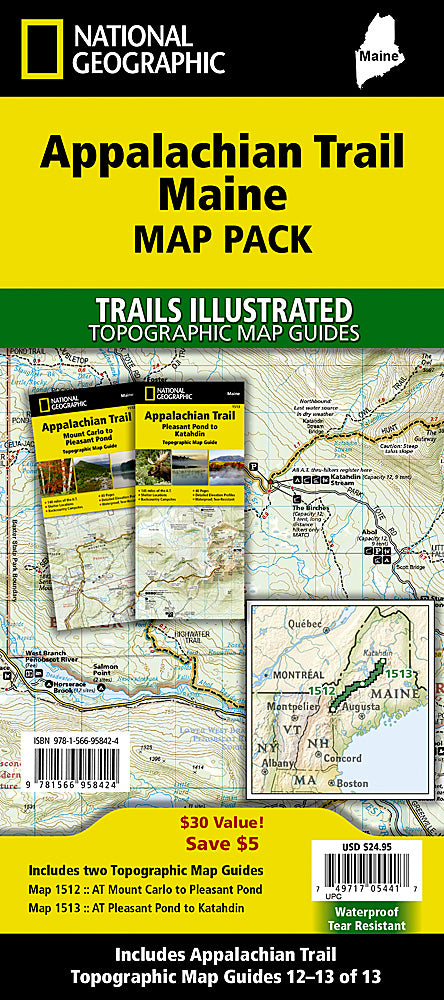
The Appalachian Trail (AT) Map Pack Bundle of Maine includes two Topographic Map Guides that cover the entire AT in the The Pine Tree State. The AT through Maine offers some of the most challenging sections of trail along the AT, both in rugged terrain and weather conditions, and is not recommended for the unprepared hiker.
Each AT Topographic Map Guide includes detailed topographic maps at a detail of 1 inch = 1 mile. Each page is centered on the A.T. and overlaps with the adjacent pages so there is little chance of getting lost. Along the bottom of each page is a trail profile that shows the distance between shelters, camping areas, and trail access points. The map and trail profile provide a step by step visual guide to hiking the trail, mile by rugged mile. The Topographic Map Guide is built for all levels of hiking enthusiasts, from the day tripper to the multi month 'thru-hiker'. The front pages of the printed Topographic Map Guide include resupply information, town inset maps, camping options, and much more.
Buy the Map Pack and save over 15%!
The Appalachian Trail: Maine [Map Pack Bundle] includes:
Map 1512 :: Mount Carlo to Pleasant Pond [Maine]
Map 1513 :: Pleasant Pond to Katahdin [Maine]
More convenient and easier to use than folded maps, but just as compact and lightweight, National Geographic's Topographic Map Guide booklets are printed on "Backcountry Tough" waterproof, tear-resistant paper with stainless steel staples. A full UTM grid is printed on the map to aid with GPS navigation.
Features:
- Accurate topography/terrain with clearly labeled details
- Full UTM grid for GPS use
- Each page provides statistics like mileages, elevations, & trailheads
- Detailed trail profile on each page
- Detailed topographic maps
- Booklet format - more convenient and easier to use than folded maps
- Waterproof and tear-resistant paper with stainless steel staples
- Model: TI01021224B
- Scale: 1:63,360
- Size: 4.25" x 9.38"
- Weight: Approx. 6.5 oz
TIP: For lower prices on our maps, check out our promotions (click the link above the picture). Here is the info: Purchase 2 - 3 maps and get 10% off, 4 or more will get you 15% off! This promo includes ALL of our maps. For example, purchase 2 Trails Illustrated maps, 1 Destination map, and 1 Adventure map (total of 4) and get 15% off!! Just put everything in your shopping cart and you will see the savings!
Requirements: None.
You will receive: 1 National Geographic Topographic Map Guide Bundle Pack.
Retail packaging, shipped in a poly envelope. Shipping weight 8 oz.
If you have any questions or concerns, please contact us before or after the sale - we want you to be a happy customer!
Thanks for looking!