NA
National Geographic TI Appalachian Trail VT East Mountain to Hanover Map TI00001510
National Geographic TI Appalachian Trail VT East Mountain to Hanover Map TI00001510
Couldn't load pickup availability
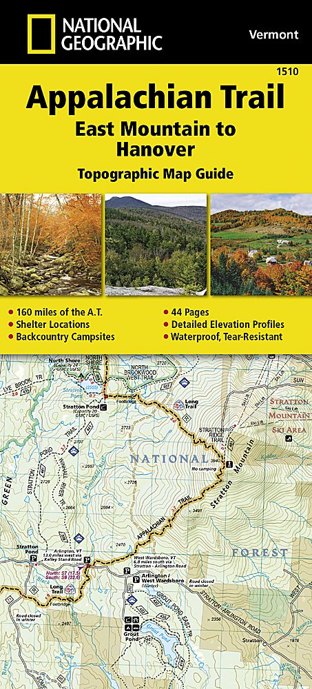
BRAND NEW National Geographic TI Appalachian Trail Vermont East Mountain to Hanover Map 1510. Great for Camping, Fishing, Hunting, Hiking, Backpacking, Family Outings, Outdoor Adventure.
More than just a map, National Geographic Trails Illustrated topographic maps are designed to take you into the wilderness and back. Printed on tear-resistant, waterproof material, this map can go anywhere you do. Each map is based on exact reproductions of USGS topographic map information, updated, customized, and enhanced to meet the unique features of each area. The maps include valuable wilderness tips and Leave No Trace guidelines, along with updated trails, trailheads, points of interest, campgrounds, and much more. With a new color palette and stunning shaded relief, backcountry navigation has never been easier.
This listing is for the Appalachian Trail Vermont East Mountain to Hanover Map 1510.
The East Mountain to Hanover Topographic Map Guide makes a perfect traveling companion when traversing the Vermont section of the Appalachian Trail (A.T.). The landscape of Vermont is a variety of wooded mountains, forests of white pine and paper birch, and rolling terrain dotted by fields and pastures. To the north and east, the A.T. crosses short, steep hills and overgrown farmlands that characterize the Connecticut River valley. Farther south is the rugged and rocky high country of the Green Mountains.
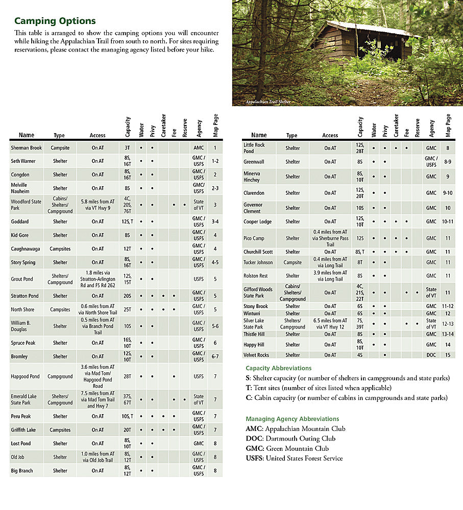
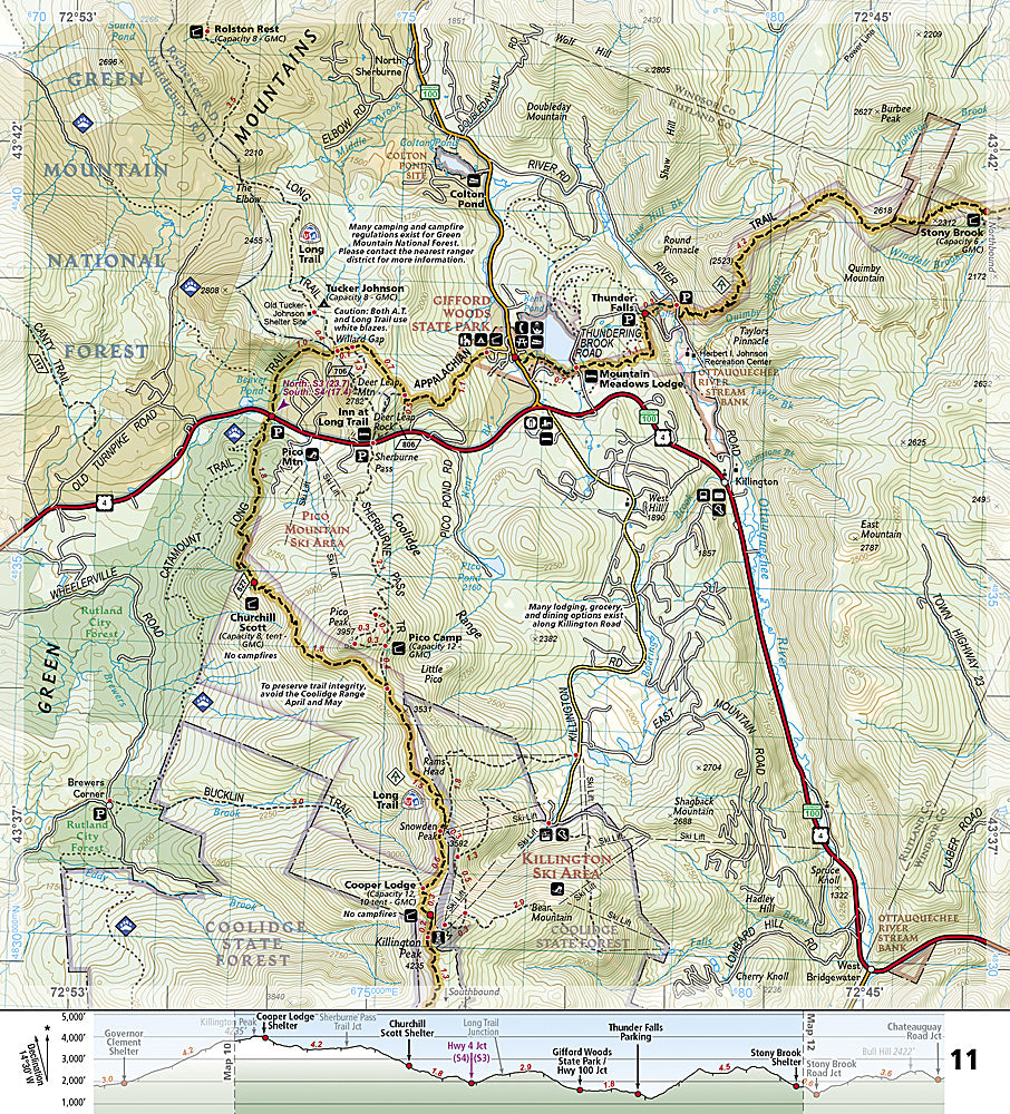
Each A.T. Topographic Map Guide includes detailed topographic maps at a detail of 1 inch = 1 mile. Each page is centered on the A.T. and overlaps with the adjacent pages so there is little chance of getting lost. Along the bottom of each page is a trail profile that shows the distance between shelters, camping areas, and trail access points. The map and trail profile provide a step by step visual guide to hiking the trail, mile by rugged mile. The Topographic Map Guide is built for all levels of hiking enthusiasts, from the day tripper to the multi month 'thru-hiker'. The front pages of the printed Topographic Map Guide include resupply information, town inset maps, camping options, and much more.
Every Topographic Map Guide is printed on 'Backcountry Tough' waterproof, tear-resistant paper. A full UTM grid is printed on the map to aid with GPS navigation. Other features found on this map include: Bennington, Big Branch Shelter, Bromley Mountain, Bromley Shelter, Churchill Scott Shelter, Clarendon Shelter, Clarksburg State Forest, Congdon Shelter, Cooper Lodge Shelter, Glastenbury Mountain, Goddard Shelter, Governor Clement Shelter, Green Mountain National Forest, Greenwall Shelter, Hanover, Happy Hill Shelter, Kid Gore Shelter, Killington Peak, Lebanon, Little Rock Pond Shelter, Lost Pond Shelter, Manchester Center, Melville Nauheim Shelter, Minerva Hinchey Shelter, North Adams, Norwich, Peru Peak Shelter, Pico Camp Shelter, Rutland, Seth Warner Shelter, Spruce Peak Shelter, Stony Brook Shelter, Story Spring Shelter, Stratton Mountain, Stratton Pond Shelter, Thistle Hill Shelter, Velvet Rocks Shelter, Wallingford, White River Junction, William B. Douglas Shelter, Winturri Shelter, Woodstock.
- Approximately 4.25" x 9.25" folded; 26.25" x 19.5" fully opened
- Scale = 1:30,000 and 1:40,000
- Waterproof, tear-resistant
TIP 1: For lower prices on our maps, check out our promotions (click the link above the picture). Here is the info: Purchase 2 - 3 maps and get 10% off, 4 or more will get you 15% off! This promo includes ALL of our maps. For example, purchase 2 Trails Illustrated maps, 1 Destination map, and 1 Adventure map (total of 4) and get 15% off!! Just put everything in your shopping cart and you will see the savings!
TIP 2: We have a huge selection and great prices on our National Geographic maps! Click here to go to our store, click on the store category called Maps & Books, then browse our sub-categories, or use the Store search tool to find items quickly.
Requirements: None.
You will receive: 1 National Geographic Appalachian Map.
Retail packaging, shipped in a poly envelope. Shipping weight 4 oz.
If you have any questions or concerns, please contact us before or after the sale - we want you to be a happy customer!
Thanks for looking!


