Trails Illustrated
Yosemite National Park Map & Day Hikes Bundle TI01021218B
Yosemite National Park Map & Day Hikes Bundle TI01021218B
Couldn't load pickup availability
BRAND NEW National Geographic Trails Illustrated Yosemite National Park Map & Day Hikes Topographic Map Guide Bundle Pack.
• Waterproof • Tear-Resistant • Topographic Map & Guide
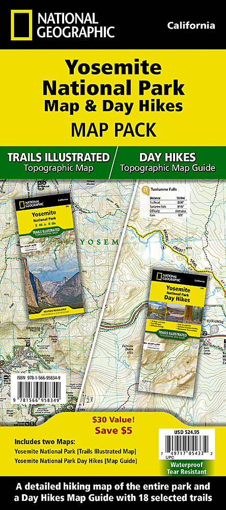
Yosemite National Park has some of the most stunning landscapes in the world. This two title Map Pack Bundle helps explorers of all levels see everything this astounding park has to offer. The map pack includes an overview map that shows the entire park as well as a Day Hikes map guide. With this combination of maps visitors can feel comfortable planning a trip to a park with options for everyone, from multi-day backpack trips to short hikes in Yosemite Valley.
The Yosemite National Park Day Hikes Topographic Map Guide includes eighteen diverse hikes for all hiking enthusiasts, from the easy, 2.8 mile long Hetch Hetchy Valley Overlook to the strenuous, 14.7 mile long Laurel Lake Trail with 3,900' of elevation gain. Each hike has a detailed map, a trail profile visualizing the changes in elevation, and a short summary of the interesting features encountered along the trip.
Buy the Map Pack and save 15%!
The Yosemite National Park and Day Hikes Map Pack includes:
Map 206 :: Yosemite National Park
Map 1704 :: Yosemite National Park Day Hikes
Every Trails Illustrated map is printed on 'Backcountry Tough' waterproof, tear-resistant paper. National Geographic's Topographic Map Guide booklets are printed on 'Backcountry Tough' waterproof, tear-resistant paper with stainless steel staples. A full UTM grid is printed on the map to aid with GPS navigation.
Features:
- Accurate topography/terrain with clearly labeled details
- Full UTM grid for GPS use
- Each page provides statistics like mileages, elevations, & trailheads
- Detailed trail profile on each page
- Detailed topographic maps
- Booklet format - more convenient and easier to use than folded maps
- Waterproof and tear-resistant paper with stainless steel staples
- Model: TI01021218B
- Scale: 1:80,000 & 1:40,000 for map, 1:40,000 & 1:20,000 for day hikes guide
- Size: 4.25" x 9.38"
- Weight: Approx. 6.5 oz
TIP: For lower prices on our maps, check out our promotions (click the link above the picture). Here is the info: Purchase 2 - 3 maps and get 10% off, 4 or more will get you 15% off! This promo includes ALL of our maps. For example, purchase 2 Trails Illustrated maps, 1 Destination map, and 1 Adventure map (total of 4) and get 15% off!! Just put everything in your shopping cart and you will see the savings!
Requirements: None.
You will receive: 1 National Geographic Topographic Map Pack.
Retail packaging, shipped in a poly envelope. Shipping weight 8 oz.
If you have any questions or concerns, please contact us before or after the sale - we want you to be a happy customer!
Thanks for looking!