NA
National Geographic Trails Illustrated Alaska Prince William Sound West Map TI00000761
National Geographic Trails Illustrated Alaska Prince William Sound West Map TI00000761
Couldn't load pickup availability
BRANDNEW National GeographicTrails Illustrated Alaska Prince William Sound WestTopo Map 761. Greatfor Camping, Fishing, Hunting,Hiking, Backpacking, Family Outings, Outdoor Adventure.
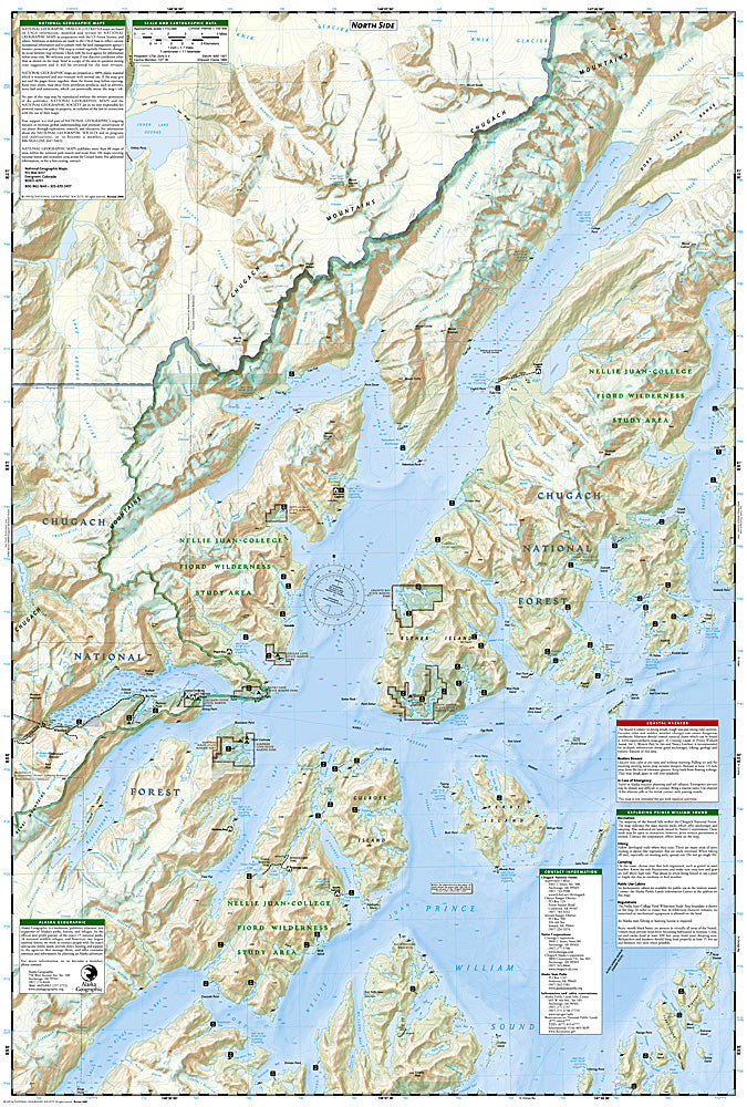
More than just a map, National Geographic Trails Illustrated topographic maps are designed to take you into the wilderness and back. Printed on tear-resistant, waterproof material, this map can go anywhere you do. Each map is based on exact reproductions of USGS topographic map information, updated, customized, and enhanced to meet the unique features of each area. The maps include valuable wilderness tips and Leave No Trace guidelines, along with updated trails, trailheads, points of interest, campgrounds, and much more. With a new color palette and stunning shaded relief, backcountry navigation has never been easier.
This listing is for theAlaskaPrince William Sound WestTopo Map 761.
TheAlaskaPrince William Sound WestTrails Illustrated map is the most comprehensive recreational map for this beautiful area of Alaska.Coverage includes Chugach National Forest, Nellie Juan-College Fjord Wilderness Study Area, Granite Bay, South Esther Island, Surprise Cove, Decision Point, Entry Cove, Ziegler Cave and Bettles Bay state marine parks. Whittier and Chenega. Knight, Latouche, Elrington, Evans, Bainbridge, Culross, Esther and Perry islands; Port Wells, Port Nellie Juan and Port Bainbridge; Harriman, College ad Blue fjords. Includes selected anchorages and kayak landings. Includes UTM tick marks for use with your GPS unit.
- Approximately 4.25" x 9.25" folded; 26" x 38" fully opened
- Scale =1:105,600
- Waterproof, tear-resistant
TIP 1:For lower prices on our maps, check out our promotions (click the link above the picture). Here is the info: Purchase 2 - 3 maps and get 10% off, 4 or more willget you 15% off! This promo includes ALL of our maps. For example, purchase 2 Trails Illustrated maps, 1 Destination map, and 1 Adventure map (total of 4) and get15% off!! Just put everything in your shopping cart and you will see the savings!
TIP 2:We have a huge selection and great prices on our National Geographic maps!Clickhereto go to our store,click on the store category called Maps & Books,then browse our sub-categories, or use the Store search tool to find items quickly.
Requirements: None.
You will receive: 1National GeographicTrails Illustrated Map.
Retailpackaging, shipped in a poly envelope. Shipping weight 4 oz.
If you have any questions or concerns, please contact us before or after the sale - we want you to be a happy customer!
Thanks for looking!