National Geographic
National Geographic Trails Illustrated CA Channel Islands National Park Map TI00000252
National Geographic Trails Illustrated CA Channel Islands National Park Map TI00000252
Couldn't load pickup availability
National GeographicTrails Illustrated California Channel Islands National ParkTopo Map 252.
More than just a map, National Geographic Trails Illustrated topographic maps are designed to take you into the wilderness and back. Printed on tear-resistant, waterproof material, this map can go anywhere you do. Each map is based on exact reproductions of USGS topographic map information, updated, customized, and enhanced to meet the unique features of each area. The maps include valuable wilderness tips and Leave No Trace guidelines, along with updated trails, trailheads, points of interest, campgrounds, and much more. With a new color palette and stunning shaded relief, backcountry navigation has never been easier.
This listing is for theCalifornia Channel Islands National ParkTopo Map 252.
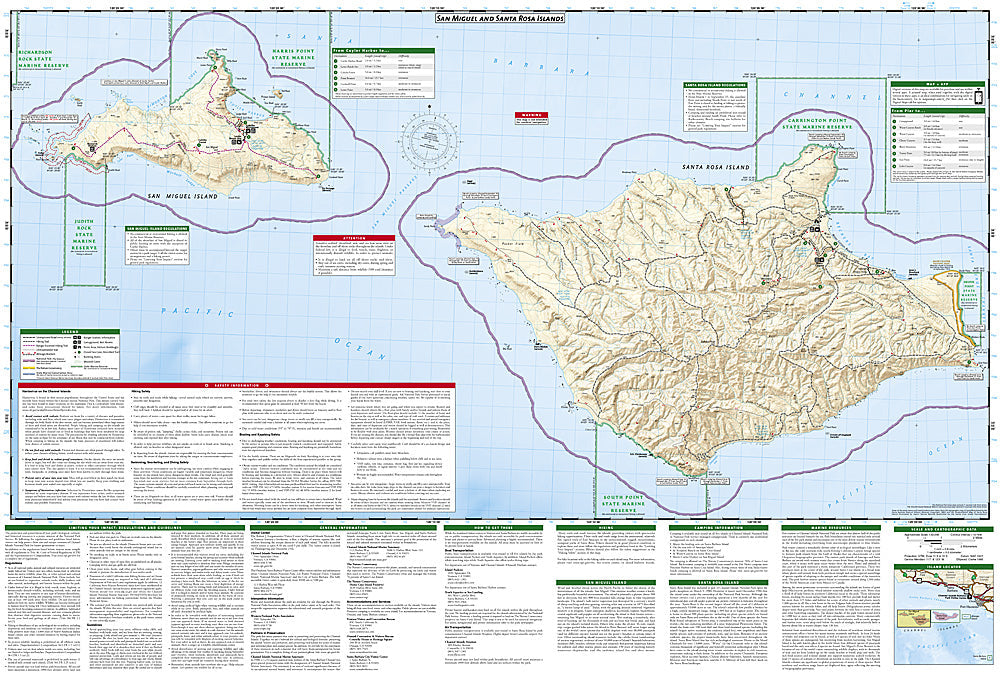
TheCalifornia Channel IslandsNational ParkTrails Illustrated map is the most comprehensive recreational map for this beautiful area of California.This two-sided map includes San Miguel Island, Santa Rosa Island, Santa Cruz Island, Santa Barbara Island, and Anacapa Island. The map combines beautiful cartography that shows the topology and natural features of each island, along with hiking trails, camping spots, rest areas, notable ship wrecks, marine reserves, and other features to help get you around each of the islands. Large scale insets of Santa Cruz's Scorpion Area, Santa Barbara Island, and Anacapa Island show trail detail, camping, picnic areas, and facilities. The map also includes a detailed description of each island, along with safety information, regulations and guidelines, hiking information and camping information. Includes UTM grids for use with your GPS unit.
Features:
- Approximately 4.25" x 9.25" folded; 26" x 38" fully opened
- Scale = 1:50,000
- Waterproof, tear-resistant
TIP:For lower prices on our maps, check out our promotions (click the link above the picture). Here is the info: Purchase 2 - 3 maps and get 10% off, 4 or more willget you 15% off! This promo includes ALL of our maps. For example, purchase 2 Trails Illustrated maps, 1 Destination map, and 1 Adventure map (total of 4) and get15% off!! Just put everything in your shopping cart and you will see the savings!
Requirements: None.
You will receive: 1National GeographicTrails Illustrated Map.
Retailpackaging, shipped in a poly envelope. Shipping weight 4 oz.
If you have any questions or concerns, please contact us before or after the sale - we want you to be a happy customer!
Thanks for looking!