National Geographic Maps
National Geographic Uncompahgre Nat Forest Map Pack Bundle TI01021253B
National Geographic Uncompahgre Nat Forest Map Pack Bundle TI01021253B
Couldn't load pickup availability
BRAND NEW National Geographic Trails Illustrated Colorado Uncompahgre National Forest Topographic Map Pack Bundle.
• Waterproof • Tear-Resistant • Topographic Maps
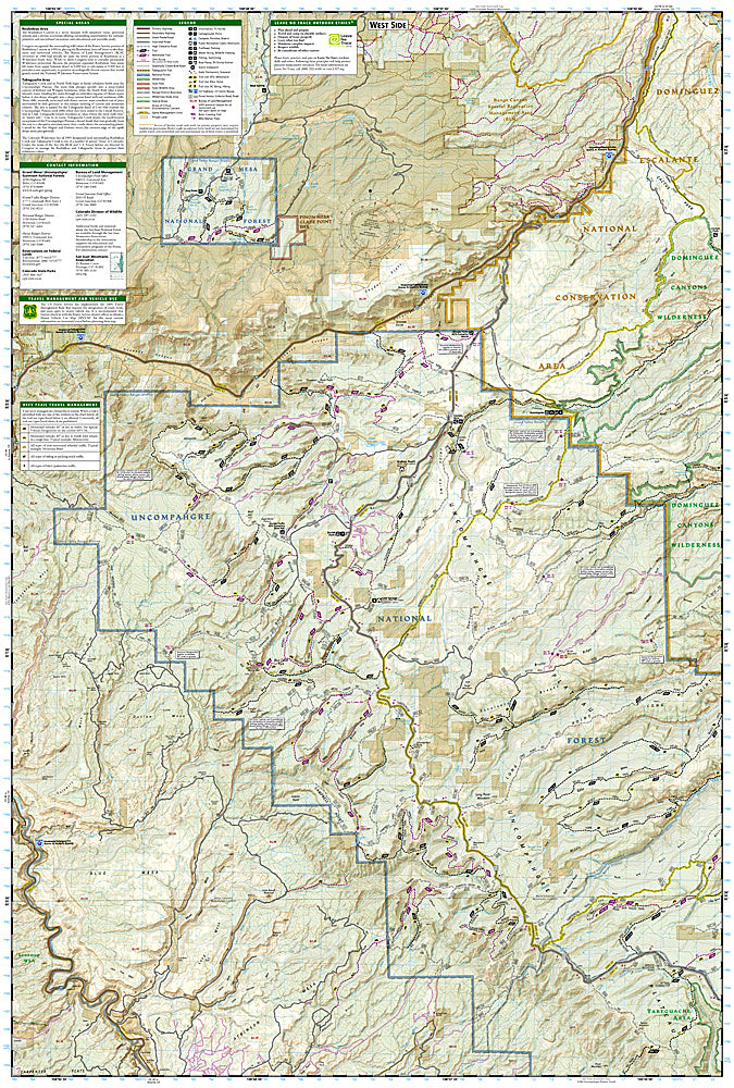
National Geographic's Trails Illustrated Map Pack Bundle of Uncompahgre National Forest is created for outdoor enthusiasts exploring the year-round recreational opportunities in this unique area in southwestern Colorado. Expertly researched and created in cooperation with the U.S. Forest Service, Bureau of Land Management and others, the map provides unparalleled detail of Uncompahgre National Forest.
Use the mapped trails, OHV routes and Forest Service roads to get off the beaten path and back on again while exploring the area's mesa and canyons. Trails are labeled according to their designated usage, whether exploring on foot, skis, horseback, mountain bike, motorcycle or ATV, including rock crawling trails. Seasonal roads and trails are labeled with their accessible dates. To aid in your navigation of the area, the maps display contour lines, elevations, labeled peaks and summits, water features, selected waypoints and clear color-coded boundaries between different land management agencies. Recreation activities include areas for camping, fishing, swimming, water skiing and wildlife viewing.
Buy the Map Pack and save over 15%!
The Uncompahgre National Forest Map Pack includes:
Map 141 :: Telluride, Silverton, Ouray, Lake City
Map 146 :: Uncompahgre Plateau South
Map 147 :: Uncompahgre Plateau North
Every Trails Illustrated map is printed on "Backcountry Tough" waterproof, tear-resistant paper. A full UTM grid is printed on the map to aid with GPS navigation.
Features:
- Waterproof, tear-resistant paper
- Accurate topography/terrain with clearly labeled details
- Full UTM grid for GPS use
- Includes regulations, permit info, and safety tips
- Hiking trail and backcountry road guides
- Route descriptions and mileages
- Detailed topographic map with contour lines, elevations, and shaded relief
- Water features with river mileage
- Mountain bike routes with degree of difficulty
- Campgrounds and campsites, scenic overlooks, and boat launch sites
- Model: TI01021253B
- Scale: 1:70,000, 1:63,360
- Folded Size: 4.25" x 9.25"
- Flat Size: 25.5" x 37.75"
- Weight: Approx. 3.4 oz each map
TIP: For lower prices on our maps, check out our promotions (click the link above the picture). Here is the info: Purchase 2 - 3 maps and get 10% off, 4 or more will get you 15% off! This promo includes ALL of our maps. For example, purchase 2 Trails Illustrated maps, 1 Destination map, and 1 Adventure map (total of 4) and get 15% off!! Just put everything in your shopping cart and you will see the savings!
Retail packaging, shipped in a poly envelope. Shipping weight 11 oz.
If you have any questions or concerns, please contact us before or after the sale - we want you to be a happy customer!
Thanks for looking!