NA
National Geographic Trails Illustrated WA Alpine Lakes Wilderness Area Map 825
National Geographic Trails Illustrated WA Alpine Lakes Wilderness Area Map 825
Couldn't load pickup availability
BRANDNEW National GeographicTrails Illustrated WashingtonAlpine Lakes Wilderness Area Trail Map 825. Greatfor Camping, Fishing, Hunting,Hiking, Backpacking, Family Outings, Outdoor Adventure.
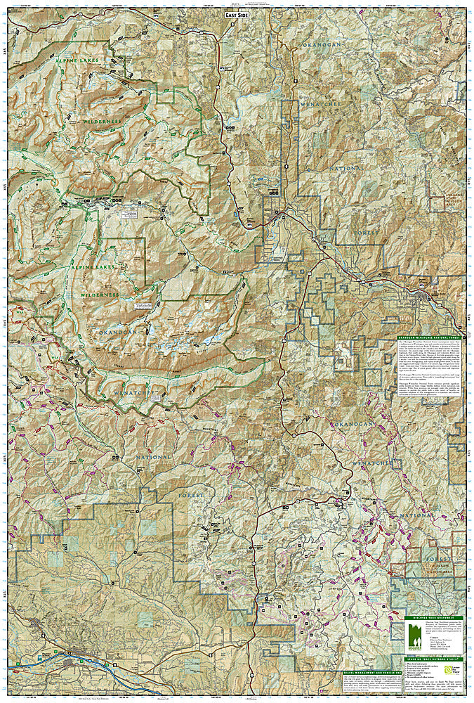
One of five Trails Illustrated maps for the Washington Cascades region offering the most detailed and up-to-date map for the forest, carefully researched and developed in co-operation with local land managers and agencies. Each map contains easy to read trails, numbered forest service roads, campsites, access points, scenic points-of-interests, and important facilities.
More than 700 lakes and mountain ponds fill practically every low spot in the glacier-carved terrain of Alpine Lakes Wilderness. Valleys thick with trees give way to rocky ridges and rugged peaks along the crest of the Cascades, some slopes permanently cloaked with snowfields. Diverse is the word that best describes the Alpine Lakes: from wet forests of Douglas fir, cedar, and western hemlock understoried with salal and berries at lower elevations on the western side; to true firs and mountain hemlock opened by extensive meadows matted with low growth; to the crest and 180 inches of precipitation per year (largely as snow); countered by spruce, whitebark pine, and larch on the eastern side; and ending farther down with a dry forestland of ponderosa pine and lodgepole pine understoried by grasses and dampened by as little as 10 inches of annual precipitation.
The Pacific Crest National Scenic Trail (PCT) enters from Stevens Pass on the north to follow the crest south, with a long westward bend to Snoqualmie Pass, a distance of 67 trail miles. Hordes of people take advantage of the PCT's 450 miles or so of excellent trails. Subsequent use and abuse of the area has resulted in a permit system, which is applied to some regions of the Wilderness between June 15 and October 15. No dogs are permitted, and campfires are banned above 5,000 feet.
Coverage includes: Pacific Crest Trail, Cle Elum, Kachess & Keechelus Lakes, Wenatchee River, Deception Falls, Stevens Pass Greenway Wilderness Coverage: Alipine Lakes.
Other Attractions: Hiking Trails, Mountain Biking, Scenic Back Roads, Boat Ramps, Mountain Climbing, Sno-Parks, Ski Areas, Fishing, Snowmobile Trails.
This listing is forWashingtonAlpine Lakes Wilderness Area Trail Map 825.
- Scale: 1:75,000 (1 Centimeter = .75 Kilometers; 1 inch = 1.18 Miles)
- Waterproof, tear-resistant
Requirements: None.
TIP: This item is also available in money-saving 2-packs and 3-packs! Go to our store, then browse our Discounted Multi-Packs Store category, or use the Store search tool to find items quickly.
You will receive: 1National GeographicTrails Illustrated Map.
Retailpackaging, shipped in a poly envelope. Shipping weight 4 oz.
If you have any questions or concerns, please contact us before or after the sale - we want you to be a happy customer!
Thanks for looking!