NA
National Geographic Trails Illustrated WA Glacier Peak Map 827
National Geographic Trails Illustrated WA Glacier Peak Map 827
Couldn't load pickup availability
BRANDNEW National GeographicTrails Illustrated WashingtonGlacier Peak Wilderness Area Trails Map827. Greatfor Camping, Fishing, Hunting,Hiking, Backpacking, Family Outings, Outdoor Adventure.
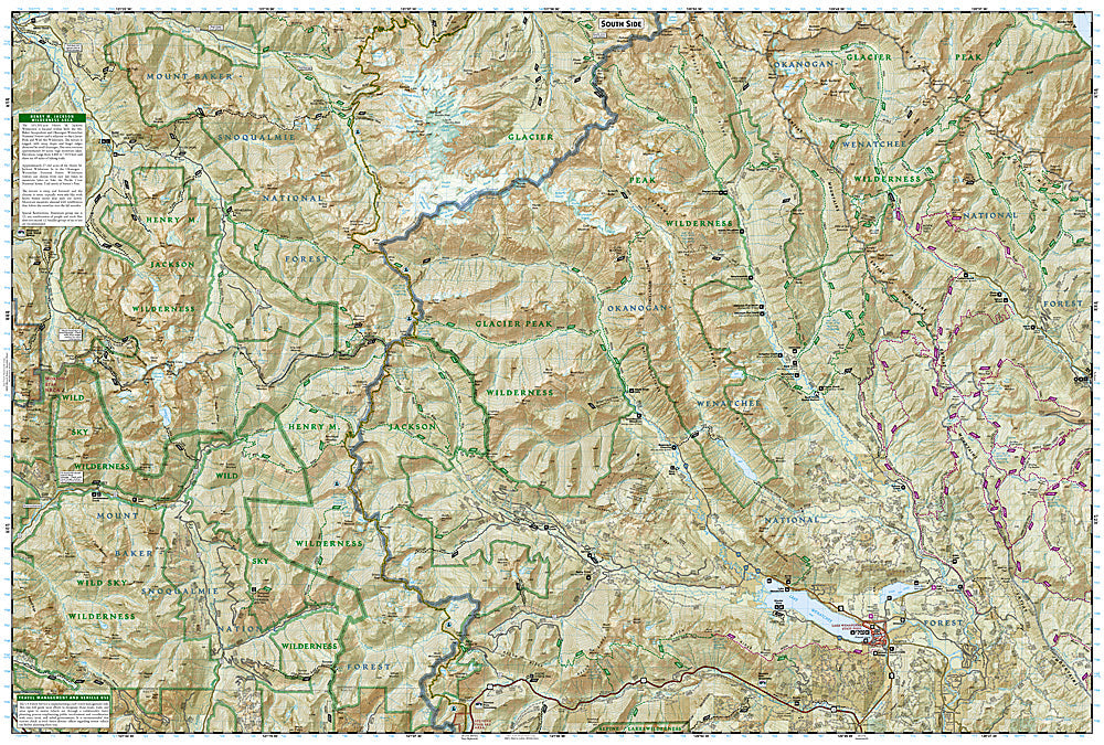
One of five new Trails Illustrated maps for the Washington Cascades region offering the most detailed and up-to-date map for the forest, carefully researched and developed in co-operation with local land managers and agencies. Each map contains easy to read trails, numbered forest service roads, campsites, access points, scenic points-of-interests, and important facilities.
The Glacier Peak Wilderness, created by Congress in the 1964 Wilderness Legislation, is located within portions of Chelan, Snohomish, and Skagit Counties in the northern Cascade Mountains of Washington State. The area, 576,900 acres in size, is characterized by heavily forested stream courses, steep-sided valleys, and dramatic glacier crowded peaks. Forest vegetation is comprised of true firs, spruce, and hemlock, as well as stands of pine on its eastern slopes. Various species of wildlife inhabit the area and include deer, elk, bear, mountain goat, cougar, marten, and lynx. The primary fishery is cutthroat trout, however, other species do exist there as well.
Recreation opportunities, as well as solitude abound with more than 450 miles of trail and many places where one can enjoy cross-country travel. Because of the popularity of the area, there have been some restrictions put in place in order to protect its unique wilderness character.
Coverage includes: Noisy Diobsud Wilderness Area, Mount Baker National Recreation Area, Skagit Wild & Scenic River, Mount Baker, Mountain Loop & North Cascades Scenic Byways Wilderness Coverage: Mount Baker, Boulder River, Noisy Diobsud.
Other Attractions: Mount Pilchuck & Wallace Falls State Parks, Baker & Spada Lakes, Lake Shannon, Hiking Trails, Mountain Biking, Scenic Back Roads, Boat Ramps, Mountain Climbing, Sno-Parks, Ski Areas, Fishing, Snowmobile Trails, Cross-Country Skiing, Waterfalls, Day Use Areas, Dispersed Camping Areas, Picnic Areas, Campgrounds.
Product Features:
- Scale: 1:75,000 (1 Centimeter = .75 Kilometers; 1 inch = 1.18 Miles)
- Waterproof, tear-resistant
Requirements: None.
TIP: This item is also available in money-saving 2-packs and 3-packs! Go to our store, then browse our Discounted Multi-Packs Store category, or use the Store search tool to find items quickly.
You will receive: 1National GeographicTrails Illustrated Map.
Retailpackaging, shipped in a poly envelope. Shipping weight 4 oz.
If you have any questions or concerns, please contact us before or after the sale - we want you to be a happy customer!
Thanks for looking!