National Geographic
National Geographic Trails Illustrated WA Mt St Helens/ Mt Adams/Gifford Map 822
National Geographic Trails Illustrated WA Mt St Helens/ Mt Adams/Gifford Map 822
Couldn't load pickup availability
National GeographicTrails Illustrated Washington Mt St Helens/ Mt Adams Wilderness Areas, Gifford Pinchot National Forest TrailTopo Map 822. Greatfor Camping, Fishing, Hunting,Hiking, Backpacking, Family Outings, Outdoor Adventure.
More than just a map, National Geographic Trails Illustrated topographic maps are designed to take you into the wilderness and back. Printed on tear-resistant, waterproof material, this map can go anywhere you do. Each map is based on exact reproductions of USGS topographic map information, updated, customized, and enhanced to meet the unique features of each area. The maps include valuable wilderness tips and Leave No Trace guidelines, along with updated trails, trailheads, points of interest, campgrounds, and much more. With a new color palette and stunning shaded relief, backcountry navigation has never been easier.
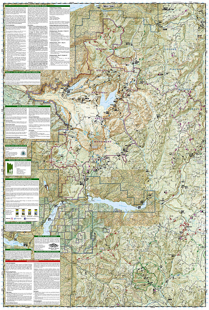
The Gifford Pinchot National Forest, located in southwest Washington State, is one of the oldest National Forests in the United States. The Forest is 1,368,330 acres in size and includes the 110,300-acre Mount St. Helens National Volcanic Monument established by Congress in 1982.
Coverage highlights: Mount Adams, Indian Haven and Trapper Creek Wilderness Areas, Mount St. Helens National Volcanic Monument, Mount Margaret Backcountry Area, Pacific Crest Trail, Spirit Lake Memorial Highway, Detailed Climbing and Permit Information.
Wilderness coverage: Mount Adams, Indian Haven, Trapper Creek.
Other attractions: Mount St. Helens National Volcanic Monument, Mount Margaret Backcountry Area, hiking trails, mountain biking, scenic back roads, mountain climbing, campgrounds, sno-parks, fishing, snowmobile trails, cross-country skiing, waterfalls.
Product Features:
- Approximately 4.25" x 9.25" folded; 26" x 38" fully opened
- Scale = 1:80,000 & 1:31,680
- Waterproof, tear-resistant
Requirements: None.
TIP:This item is also available in money-saving 2-packs and 3-packs! Go to our store, then browse our Discounted Multi-Packs Store category, or use the Store search tool to find items quickly.
You will receive: 1National GeographicTrails Illustrated Map.
Retailpackaging, shipped in a poly envelope. Shipping weight 4 oz.
If you have any questions or concerns, please contact us before or after the sale - we want you to be a happy customer!
Thanks for looking!